Showing posts with label cherokee. Show all posts

Wednesday, July 17, 2013

The Battle of Honey Springs (Elk Creek), Oklahoma (July 17, 1863)

War-time Sketch of the Battle of Honey Springs, Oklahoma
150 years ago today on July 17, 1863, having skirmished with Confederate forces at Chimney Mountain, the Union army of Maj. Gen. James G. Blunt reached the battlefield at Honey Springs, Oklahoma. Please click here to read about the preliminary skirmish at Chimney Mountain.

Halting his men at the northern end of today's Honey Springs Battlefield State Historic Site, Blunt gave them time to rest while he and his escort scouted the position of Brigadier General Douglas H. Cooper's Confederate army.

Scene of Heavy Fighting early in the Battle
Although each general believed he was heavily outnumbered, their two effective forces were fairly close in size (about 3,000 men each). The Confederates had a few more men, but many never were engaged and all were experiencing problems with faulty ammunition. Under the rainy conditions that day quite often their guns would not fire.

As he arrived on the field, Blunt discovered that the Confederate army was positioned in thick brush and timber facing open ground across which his men would have to advance. Seeing that Cooper was prepared to fight, he ordered his men into the ranks:

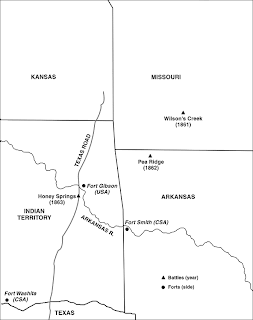
Map showing location of the Battle
Courtesy National Park Service
...After two hours' rest, and at about 10 a.m., I formed them in two columns, one on the right of the road, under Colonel [William R.] Judson, the other on the left, under Colonel [William A.] Phillips. The infantry was in column by companies, the cavalry by platoons and artillery by sections, and all closed in mass so as to deceive the enemy in regard to the strength of my force. In this order I moved up rapidly to within one-fourth of a mile of their line, when both columns were suddenly deployed to the right and left, and in less than five minutes my whole force was in line of battle, covering the enemy's entire front. - Maj. Gen. James G. Blunt, USA.

The Union force then moved forward, with skirmishers out front, and "soon drew their fire."

On the Confederate side of the field, General Cooper waited until the Union troops were within easy range and then opened on them with his artillery:

Elk Creek on the Honey Springs Battlefield
...I rode forward to the position north of Elk Creek where Captain [R.W.] Lee's light howitzer battery had been posted, and found it supported by Colonel Bass' regiment (Twentieth Texas Dismounted Cavalry), by a portion of the Second Cherokee  Regiment, and a body of skirmishers on the right, under command of Captain Hugh Trinn, of the First Cherokee Regiment, the remainder of the Cherokee Regiments being near the Creek. - Brig. Gen. Douglas H. Cooper, CSA.

Things quickly began to go wrong for the Confederates. General Cooper arranged his forces for a defense in detail, which allowed the Federal troops to put more power into position against his front lines. Col. Tandy Walker, meanwhile, mistook his orders and moved far out of position with his Cherokee and Creek troops.

Texas Road on the Honey Springs Battlefield
As Captain R.W. Lee and the men of his battery had watched, the Federals had begun to wheel 12 pieces of artillery into position. Rather than let them get this superior artillery force into position, Lee opened on the guns with his howitzers and a small experimental rifled cannon. A Union cannon was demolished by Confederate fire, but the Federals soon found the range and returned effect fire.

Heavy fighting erupted up and down the line but after two hours, the critical moment of the battle came. Confederate officers mistook a re-positioning of a portion of the Union line and thought a retreat had gun. They ordered an immediate counter-attack. The Confederates surged forward to within just 25 paces of the Union lines when the 1st Kansas Colored Volunteers suddenly unleashed a deadly volley on them. The charge was shocked to a stop as dozens of men fell dead and wounded.

Site of the Elk Creek Bridge on the Battlefield
At this point the Confederate line began to fall back for the crossings of Elk Creek and General Cooper ordered his men to withdraw. A force of Texas soldiers held the vital Elk Creek Bridge on the Texas Road under heavy fire, giving Cooper time to withdraw most of his men.

The Southern forces continued to fight, but their faulty ammunition caused so many problems that they began to lose hope. A retreat degenerated into a rout.

As total disaster seemed about to overwhelm the Confederate army, Col. Tandy Walker suddenly arrived on the field with his Cherokee and Choctaw soldiers. Cooper immediately ordered them to charge:

Site of Walker's Charge at Honey Spring
...With their usual intrepidity the Choctaws went at them, giving the war-whoop, and succeeded in checking the advance of the enemy until their force could be concentrated and brought up. The Choctaws, discouraged on account of the worthless ammunition, then gave way, and were ordered to fall back with the others in the rear of the train, which had moved off in an easterly direction, covered by our own troops.... - Brig. Gen. Douglas H. Cooper, CSA.

The "Gettysburg of the West" had been fought - and lost - by the Confederates and the end of the battle found them in full retreat for the Canadian River and the reinforcement column then coming up under General Cabell.  Cooper ordered his supplies that could not be saved set afire and by the time the Federals occupied their camps, there was little left to capture. General Blunt did report taking one piece of artillery, 200 stand of arms, 15 wagons and one stand of colors.

Monuments at Honey Springs Battlefield
The Battle of Honey Springs (sometimes called the Battle of Elk Creek) shifted the war in the far west from the Cherokee and Creek Nations all the way south into the Choctaw Nation. It opened the door for Blunt's capture of Fort Smith in September. Great misery would follow in the Creek, Choctaw and Chickasaw Nations as the Union troops pushed south over coming months and thousands of American Indian refugees would flee south for the Texas line, the smoke from their burning homes filling the skies behind them.

The battle will be reenacted in November, when the weather is a little cooler, and a major weekend of activities is planned for the 150th anniversary commemoration at the same time.

To learn more, please visit www.exploresouthernhistory.com/honeysprings1.


Tuesday, July 19, 2011

Amicalola Falls State Park - Dawsonville, Georgia

Amicalola Falls
Located in the heart of the North Georgia mountains, Amicalola Falls State Park is home to the tallest cascading waterfall in the South.

Four times taller than Niagra Falls, Amicalola Falls is formed by Little Amicalola Creek as it roars its way down the mountain on its way to the Etowah River. The total height of the waterfall is 729 feet and the name is thought to be a Native American word that means "tumbling waters."

The falls were, of course, well known to the early Cherokee and their prehistoric ancestors, both of whom called this part of Georgia home. The Cherokee continued to live in the area until 1838 when they were forced from their homes and driven west on the Trail of Tears. Six years before that, though, a Georgia surveyor saw and described Amicalola Falls. He even tried to climb to the top but like many visitors today, he found the effort was a bit too strenuous for him.

Little Amicalola Creek
With the departure of the Cherokee, the falls area was opened for white settlement. A water mill was built just below the landmark in 1852 and a Methodist campground was established there in 1860.

Today the area around the falls is part of a magnificent Georgia state park. Established in 1940, Amicalola Falls State Park features the waterfalls, seasonal trout fishing, hiking trails, picnic areas, camping areas, cabins, a lodge, visitor center and, of course, great views of the falls.

To learn more about Amicalola Falls, please visit www.exploresouthernhistory.com/amicalolafalls.

Friday, May 14, 2010

14 Flags Museum - Sallisaw, Oklahoma

Some of the most fascinating historic places in the South are the small locally-operated museums that dot the landscape. Among these is the 14 Flags Museum in Sallisaw, Oklahoma.

Located at the intersection of U.S. Highways 59 and 65 in downtown Sallisaw, the outdoor museum features a fascinating collection of historic structures. Among these are log cabins that date to the earliest days of Cherokee settlement in eastern Oklahoma before and immediately following the Trail of Tears.

The Lattimore cabin, shown here, is an outstanding example. Thought to have been built in around 1835 by Samuel Lattimore, an early Cherokee settler. The logs were felled and squared by hand and still bear the marks of the axes and adzes used by builder. A loophole in the east wall is a reminder of the turbulent days that the Cherokee settlers experienced after arriving in their new homes. Not only did they sometimes battle with Indian tribes already living in the area, but they also lived through the brutal days of the Civil War in the Indian Nations and the outlaw years that followed.

Other structures at the museum include the Judge Faulkner cabin which was built in the 1840s and occupied at various times by both Union and Confederate troops during the War Between the States; the old Sallisaw Train Depot; a log cabin containing a Trail of Tears exhibit and more.

To learn more about the 14 Flags Museum, which receives its name from the 14 identifiable tribes and nations that occupied this part of Oklahoma, please visit www.exploresouthernhistory.com/sallisawmuseum.

Tuesday, January 6, 2009

Sequoyah and the Cherokee Alphabet


One of the most significant scholarly accomplishments of the 19th century was achieved by a disabled Cherokee warrior working quietly in a crude log cabin near the present city of Fort Payne, Alabama.

Sequoyah, also known by the "white" name of George Gist or Guess, had located to Wills Town, a major Cherokee settlement in Alabama, in 1818. Born in Tennessee in around 1770, he had served with U.S. allied Cherokee forces under Andrew Jackson at the Battle of Horseshoe Bend, Alabama, in 1814.

In the years following the Battle of Horseshoe Bend, Sequoyah became convinced that the reason white civilization was advancing much more rapidly than that of the various Native American tribes was because the whites had developed a way of communication with each other in writing.

The more he thought about the possibilities of a written Cherokee language, the more Sequoyah decided to make the development of one a personal quest. Despite ridicule from family and friends, he began work on the project. It would take years to complete.

In 1821, however, Sequoyah successfully demonstrated his Cherokee Alphabet. Over the next few years leaders in the nation became convinced of the remarkable nature of his effort and the use of the written Cherokee language spread like wildfire. In 1825 the Cherokee became the first Native American nation to publish their own newspaper in their own language. Sequoyah's alphabet had become the first official written language in Indian history.

To learn more about Sequoyah and his remarkable alphabet, please visit our new Sequoyah pages at www.exploresouthernhistory.com/sequoyah.


Monday, January 5, 2009

Wills Town Mission - A Cherokee Cemetery in Alabama


One of the most fascinating historic sites I've visited in a long, long time can be found on the outskirts of Fort Payne, Alabama.

Wills Town Mission, a Christian mission to the Cherokee Indians that operated from 1823 until the Trail of Tears in 1838, is marked today by a unique cemetery on 38th Street just south of its intersection with Godfrey Avenue in Fort Payne. First used by the Cherokee inhabitants of Wills Town, a major Native American village, the cemetery was later used by 19th century white settlers as well.

The Cherokee graves are marked by natural stones, some of which exhibit faded symbols and carvings, and the stumps of cedar trees. It is reported locally that the trees were cut years ago for building materials by a previous owner of the site. The cemetery is now preserved and marked by a historical marker and a stone monument.

Wills Town was a significant settlement among the Cherokee of Alabama prior to the Trail of Tears. It was in the vicinity that Sequoyah completed his development of the Cherokee alphabet in 1821, giving the Cherokee Nation the only written language of any Native American nation.

The Christian mission in the town converted many members of the tribe to Christianity and also provided education in English, etc., to the inhabitants of Wills Town. The people of the village, however, were among those forced west under the guns of soldiers on the long and deadly march remembered today as the Trail of Tears.

To learn more about Wills Town and its unique Cherokee cemetery, please visit www.exploresouthernhistory.com/fortpayne2.