Saturday, August 20, 2011

Archaeologists bring story of Civil War prison camp to life

Archaeological Excavation at Camp Lawton
A second season of research by archaeologists from Georgia Southern University is adding a great deal to our understanding of life at Camp Lawton, a Civil War prison camp near Millen, Georgia.
Millen is about an hour south of Augusta and was along the route of Sherman's March to the Sea. Camp Lawton had only been in use for about six weeks when the approach of Sherman's army forced its evacuation. During that short time of operation, however, more than 10,000 Union prisoners of war were confined in the 42-acre stockade and over 700 died.

Stream and Prison Site
The site has long been preserved as part of Magnolia Springs State Park and the adjacent Bo Ginn National Fish Hatchery. Because of this preservation, the site of the stockade and its related components has been protected for years and the artifacts associated with the prison and its inmates have been left in the ground where they fell nearly 150 years ago.

Interpretive Kiosk at Camp Lawton Site
As archaeologists uncover these artifacts, they are pushing away the fog of time to learn much about what life was like in the prison. Not only has their work revealed traces of the stockade and other structures, it has located places where prisoners lived. Artifacts found so far include a unique ring, traces of huts lived in by prisoners and even buckles and other items bearing regimental insignia. The latter items help pinpoint where men from various units lived in the prison.

In addition to the prison site itself, Magnolia Springs State Park features the well-preserved earthworks of the Confederate fortifications that surrounded the stockade. In addition, there are interpretive panels and signs to help visitors learn about the prison and its history.

To learn more about Camp Lawton, please visit www.exploresouthernhistory.com/camplawton.

Sunday, August 7, 2011

Kennesaw Mountain National Battlefield Park - Kennesaw, Georgia

Kennesaw Mountain Battlefield
A park that commemorates the Atlanta Campaign and preserves the scene of some of its heaviest fighting, Kennesaw Mountain National Battlefield Park is a rare Civil War landscape in the rapidly spreading Atlanta metropolitan area.
Fought on July 27, 1864, the Battle of Kennesaw Mountain was one of the few direct Union assaults of Gen. William Tecumseh Sherman's campaign to take Atlanta. The Federal troops tried to storm heavily fortified position along the slopes of the mountain but were hurled back with severe losses. More than 4,000 men were reported killed, wounded or missing in just a few short hours.

Cannon on top of Kennesaw Mountain
The battle developed as Sherman pushed the last few miles to the Chattahoochee River, beyond which no natural barriers separated him from the vital rail junction of Atlanta. To reach the river, however, there was one more great natural barrier to pass - Kennesaw Mountain and its connected ridges.

The high ground, however, was held by the outnumbered but still determined Confederate Army of Tennessee led by Gen. Joseph E. Johnston. His Southern forces had entrenched themselves heavily on the mountain and connected slopes and his cannon were firing from the summit of the mountain on the trains that brought Sherman's supplies down from Tennessee.

Monument at the Dead Angle
Recent rains had made a flanking maneuver too difficult to undertake, so on the morning of July 27, 1864, Sherman hurled his forces at the mountain.  The attack went wrong almost immediately. The Confederate positions were just too strong and the Union attacking columns were swept by Southern cannon and musket fire.

The Confederate victory at Kennesaw Mountain would be the last Southern triumph of the Atlanta Campaign. Five days later Sherman was able to move his army around one of Johnston's flanks and Southern troops were forced to give up the mountain and fall back first on the line of the Chattahoochee and soon into the defenses of Atlanta itself.  Johnston was replaced by Gen. John Bell Hood who launched poorly coordinated and futile attacks on Sherman's forces, decimating his army and losing Atlanta in the process. The fall of the city drove a bayonet into the heart of the Confederacy.

To learn more about this beautifully preserved battlefield, please visit www.exploresouthernhistory.com/kennesaw.

Saturday, July 23, 2011

Ghost of Allatoona Pass - A 19th Century Haunting in Georgia

Tracks near Allatoona Pass
Much as American newspapers did with UFOs in the 1950s, the papers of the 19th century often covered reports of ghost sightings as hard news. As a result, some of the best documented alleged ghost appearances in American history are those that took place during the 1800s.

One particularly unique story involves a ghost that appeared on the trains of the Western & Atlantic Railroad (W&A) during the years after the Civil War.

Deep Cut at Allatoona Pass
According to an 1872 issue of the Atlanta Journal, the ghost appeared on trains as they passed along the stretch of tracks between Allatoona Pass and Tilton, a crossing not far from Dalton in North Georgia.

...This individual appears suddenly on top of the freight cars, takes a seat and remains there for many miles, then the unknown brakesman disappears. Conductors, seeing him, have often gone out to collect his fare, but on nearing him, he would vanish like mist. - Atlanta Journal, Dec. 1872.

The spectre most often appeared as the trains steamed out of the Deep Cut at Allatoona Pass and picked up speed.This prompted speculation among the railroad men that it might be the ghost of a Civil War soldier killed in the frightful battle at the pass on October 5, 1864.

The ghost did not attempt to frighten anyone and seemed more like the mere image of a man than a troubled spirit. It simply sat atop a freight car on the train. It made no sound. It did not move. It was almost as if it were a photograph on the air.

A number of train crews saw the figure and finally a particularly brave engineer decided to get to the bottom of the mystery. Learn what he discovered and read more about the Ghost of Allatoona Pass by visiting www.exploresouthernhistory.com/allatoonaghost.

Thursday, July 21, 2011

Battle of Allatoona Pass, Georgia - First Battle of the Franklin & Nashville Campaign

Monuments at Allatoona Pass Battlefield
Not far from Cartersville in Bartow County, Georgia, a beautiful battlefield park preserves the scene of the Battle of Allatoona Pass.

The first battle of Confederate General John Bell Hood's Franklin & Nashville Campaign, the fight took place on October 5, 1864, when Hood sent General Samuel G. French's division to take the Union forts that guarded the Deep Cut at Allatoona Pass. The cut, dug to a depth of 175 feet through the solid rock of the Allatoona Mountains, provided a usable grade for the trains of the Western & Atlantic (W&A) Railroad. This single track was the only source of supplies for General William Tecumseh Sherman's Union army then occupying Atlanta.

Deep Cut at Allatoona Pass
French was to capture and fill the cut before destroying the nearby bridge over the Etowah River, all part of Hood's grand plan to cut off Sherman's supply line even as the Confederate army slipped away through Alabama to Tennessee for a move on Nashville.

It did not take Union scouts long to realize that French was on the move with his 3,276 man division. From a tower on the top of Kennesaw Mountain near Atlanta, Sherman had messages sent by signal flag urging the 976 Union soldiers guarding Allatoona Pass to hold on until reinforcements could reach them. A Northern officer later remembered the message as saying, "Hold the fort; I am coming."

Earthworks of the Star Fort
In 1870, evangelist and composer Philip Paul Bliss heard Major Daniel Webster Whittle tell the story at a Sunday School convention in Illinois. So moved was he by it that he soon wrote the Christian hymn, "Hold the Fort." It remains a favorite in America's churches to this day and, strangely, has also been adopted - although with altered lyrics - as a rally song by the labor unions of Great Britain and the Carribean.

Sherman's two messages actually said "Sherman is moving in force; Hold Out!" and "General Sherman says Hold Fast. We are coming." When asked about the song in later years he said that while he never sent the message "Hold the Fort," that was certainly the intent of his messages.

The Union troops at Allatoona Pass did indeed "Hold the Fort." In a bloody mountaintop battle, they repelled four separate attacks on the Star Fort by the veterans of French's Division.

To learn more about the Battle of Allatoona Pass, the writing of the song "Hold the Fort" and to take an online tour of the battlefield, please visit www.exploresouthernhistory.com/allatoonapass.

Wednesday, July 20, 2011

Faulty Reporting Ignites National Debate over Alabama's Confederate Memorial Park

Confederate Memorial Park
There is a lot of misinformation ricocheting around today about Confederate Memorial Park in Mountain Creek, Alabama.

An Associated Press report on the park has been picked up by newspapers, National Public Radio, the liberal Huffington Post and a host of other websites and blogs. The original report basically takes the premise that the State of Alabama is spending tax money to care for a park located on the grounds of the state's former Old Soldiers Home while other historic sites are in need of funding.

The idea the writer is attempting to convey, of course, is that state money is being spent on a Confederate landmark while other "more deserving" historic sites do not have the funding they need.

Cemetery at Confederate Memorial Park
First and foremost, its name aside, the park is NOT a Confederate landmark nor was the site involved in the War Between the States. In 1901, a new State Constitution was approved in Alabama that included a provision for a small amount of the state's taxes to be used in providing care for its elderly and disabled Confederate veterans. Union veterans received help from the U.S. Government, but Confederate veterans did not and the responsibility of caring for hundreds of needy and elderly veterans fell upon the people of the state. Otherwise, many of these men would have died homeless.

The inclusion of this item in the state's constitution was not intended to memorialize the Confederacy. Instead it was done to care for aged veterans that the U.S. Government had decided to ignore and forget. Over the years, the home provided a place to live and medical care for hundreds of veterans, many of whom were impoverished due to horrible wounds they had received in battle. Its cemeteries provided a final resting place for them.

Despite much of what is being written on blogs and message boards today, the funding was not a "Confederate tax," nor was it tied to the "Civil War." It simply was a humanitarian gesture to care for old men who had nowhere else to turn - a form of government healthcare, if you will.

Museum Exhibits
The park today preserves the historic grounds and ruins of the Old Soldiers Home and maintains the two cemeteries where more than 300 Alabama solders are buried. The museum there, contrary to much of what is being written there, is not a "Confederate museum." It is a museum that looks at Alabama's role in the War Between the States or Civil War from all perspectives. It does include exhibits on slavery, but also looks at how the war impacted the state. It presents a good balanced view of the war in Alabama and a visit is highly recommended to anyone traveling up and town I-65 between Montgomery and Birmingham.

This controversy is absolutely and totally ridiculous. Why should graves not be maintained and what is wrong with Alabama funding a museum that provides a balanced look at the Civil War?

After all, doesn't the U.S. Government do the same thing at its national parks and cemeteries?

To learn more about Confederate Memorial Park, please visit www.exploresouthernhistory.com/confederatepark.

Tuesday, July 19, 2011

Amicalola Falls State Park - Dawsonville, Georgia

Amicalola Falls
Located in the heart of the North Georgia mountains, Amicalola Falls State Park is home to the tallest cascading waterfall in the South.

Four times taller than Niagra Falls, Amicalola Falls is formed by Little Amicalola Creek as it roars its way down the mountain on its way to the Etowah River. The total height of the waterfall is 729 feet and the name is thought to be a Native American word that means "tumbling waters."

The falls were, of course, well known to the early Cherokee and their prehistoric ancestors, both of whom called this part of Georgia home. The Cherokee continued to live in the area until 1838 when they were forced from their homes and driven west on the Trail of Tears. Six years before that, though, a Georgia surveyor saw and described Amicalola Falls. He even tried to climb to the top but like many visitors today, he found the effort was a bit too strenuous for him.

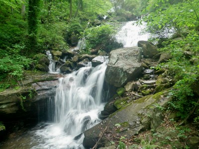
Little Amicalola Creek
With the departure of the Cherokee, the falls area was opened for white settlement. A water mill was built just below the landmark in 1852 and a Methodist campground was established there in 1860.

Today the area around the falls is part of a magnificent Georgia state park. Established in 1940, Amicalola Falls State Park features the waterfalls, seasonal trout fishing, hiking trails, picnic areas, camping areas, cabins, a lodge, visitor center and, of course, great views of the falls.

To learn more about Amicalola Falls, please visit www.exploresouthernhistory.com/amicalolafalls.

Friday, July 15, 2011

War Eagle Mill & Bridge - Northwest Arkansas

War Eagle Mill & Bridge
One of the most charming scenes in the Ozarks of Northwest Arkansas is the view of the War Eagle Mill and Bridge from across the historic mill pond.

The current structure is the latest version of a mill that has stood on the banks of War Eagle Creek (sometimes called the War Eagle River) since the 1830s. Originally built by Sylvanus Blackburn, the mill was a thriving enterprise for two decades before the Civil War.

War Eagle Mill
The first structure was washed away by a flood in 1848, but was quickly replaced. When the Civil War swept with brutal force across the Ozarks, the War Eagle Mill was used to grind grain for both the Union and Confederate armies (at different times, of course!). After the Battle of Pea Ridge, a portion of General Earl Van Dorn's shattered Southern army passed by the mill during their retreat from the battlefield.

The second mill, like most such structures in the region, did not survive the war but was burned before the end of the conflict. The brutual economic conditions of the years after the Civil War prevented the rebuilding of War Eagle Mill until 1873. After it returned to operation, however, the mill served the people of the area for many decades to come.

The present structure, completed in 1973, is the fourth operating mill to stand on the site and is a recreation of previous structures. It is open to the public and is the focal point of major art & craft shows each fall and spring. It is also one of the most picturesque locations in Northwest Arkansas.

To learn more about War Eagle Mill, please visit www.exploresouthernhistory.com/wareagle.

Tuesday, July 12, 2011

The Wild Man - 19th Century Bigfoot Sightings in Arkansas

Swamps of Eastern Arkansas
It might be a common perception that the first recorded sightings of the gigantic, hair-covered creature known as Bigfoot took place in the Pacific Northwest, but this is not true.

As hunters and settlers pushed deeper into the wooded frontiers of the early South, they often came into a contact with a monster that they usually called the "Wild Man of the Woods." Mirroring modern-day accounts by eyewitnesses who say they have seen Bigfoot, the 19th century reports indicate the Wild Man was a gigantic, hair-covered creature with unusually large feet.

Some of the most compelling written accounts originated in Arkansas in the 1840s, although these same reports indicated the monster had been seen there as early as 1834. In 1846, however, a newspaper story spread across the nation reporting a sighting near Crowley's Ridge west of Memphis. The monster's track, it was said, "measures 22 inches, his toes are as long as a common man's fingers, and in height and make, he is double the usual size."

Ouachita Mountains of Arkansas
The description of the footprints clearly is almost identical with modern accounts and is one of the earliest recorded descriptions of a Bigfoot's tracks.

The sightings in Arkansas continued to be covered by the nation's newspapers until the eve of the Civil War when, of course, other news took priority. By the time the war ended, the Arkansas Wild Man had almost been forgotten, although the term "Arkansas Wild Man" continued to be used to describe rowdier residents of the Natural State.

There are, of course, Bigfoot sightings in Arkansas to this day and the southwest corner of the state is famed for its Fouke Monster (immortalized in the low budget film "The Legend of Boggy Creek"). But the historical 19th century accounts survive as some of the earliest accounts of the mysterious creature and as such are a unique part of the history of the Natural State.

To read a full account, please visit www.exploresouthernhistory.com/arwildman.

Friday, July 8, 2011

Columbia, Alabama - Historic Sites & Points of Interest

Purcell-Killingsworth House in Columbia
A charming and historic community nestled along the Chattahoochee River in the Wiregrass region of Southeast Alabama, Columbia is an often overlooked heritage destination that is well worth a visit.

Founded in 1820 as settlement spread across lands taken from the Creek Nation by the Treaty of Fort Jackson, Columbia was an important river crossing and port community even from its earliest days. The arrival of steamboat traffic on the Chattahoochee River just a few years later, however, spurred a boom that made the town one of the most prosperous on the river between Eufaula, Alabama and Apalachicola, Florida.

Old Columbia Jail
The cotton and other commerce for a significant area of the Wiregrass region (named for a tough, wire-like grass that grows in the pine woods) passed through Columbia, where it was loaded aboard paddlewheel riverboats for transport up to Columbus or down to Apalachicola on the Gulf. This spurred a strong commercial district with stores, warehouses and other businesses. The town for a time was even the county seat, although that status was lost as the vast expanse of the original Henry County was carved up into numerous other counties as the population of the region grew.

Columbia remained a vital river port until the railroad was finally extended into South Alabama during the last decades of the 19th century. The town on the river was bypassed in favor of a new community - Dothan - and Columbia's commercial interests slowly faded.

Summer House at Columbia Cemetery
The town survived, however, and today is the center of a unique, picturesque and historic area with many points of interest. The historic Old Columbia Jail, for example, dates from the Civil War and is one of the last surviving original wooden jails in the Deep South. The unique summer house that serves as an entrance way to Columbia Cemetery is more than 100 years old.

There are charming historic homes and churches, including the architecturally unique Purcell-Killingsworth House. Just four miles or so away across the river in Early County, Georgia, stands the beautiful Coheelee Creek Covered Bridge. The southernmost 19th century covered bridge in the nation, it spans a charming little waterfall.

To learn more about Columbia and the surrounding area, please visit www.exploresouthernhistory.com/columbia.

Thursday, June 30, 2011

Cedar Falls at Petit Jean State Park - Magnificent Arkansas Waterfall

Cedar Falls at Petit Jean Mountain
One of the most spectacular waterfalls in the Natural State, Cedar Falls plunges 90 feet into Cedar Creek Canyon at Petit Jean State Park near Morrilton, Arkansas.

Fed by Cedar Creek, which flows from the top of Petit Jean Mountain and over the waterfall into a beautiful canyon surrounded by towering pluffs and natural rock palisades, Cedar Falls is perhaps the best known waterfall in Arkansas. A centerpiece of the state's oldest state parks, the falls have been photographed by untold thousands of visitors over the decades since Petit Jean State Park was created.

The area around the waterfall is unique because the impetus to preserve it came not from the state or federal government, but from a group of logging company executives who met there in 1907 to inspect the area's timber potential. After spending a weekend exploring the area and marveling at its stunning beauty, they unanimously agreed that its trees should be allowed to continue their natural growth and that the remarkable setting should be preserved for future generations.

View from Petit Jean Mountain
It would take many years for this dream to be realized. The U.S. Government turned down the land as a national park because the tract was not then considered large enough for park purposes. The effort to donate the land for public use then turned to the Arkansas State Legislature. After negotiating some red tape, the state acquisition of its first state park lands took place in 1921.

The development of Petit Jean State Park, particularly the area around Cedar Falls, was carried out largely by the Civilian Conservation Corps during the Great Depression. Company 1781 was assigned to the park and spent the years from 1933 to 1938 building trails, roads, bridges, pavilions, cabins and the beautiful stone Mather Lodge (currently closed for renovation).

Ancient Indian Art
The park today preserves 2,568 acres of stunning mountain scenery. In addition to Cedar Falls and the spectacular canyon, there is a mountain top scenic drive, stunning overlooks, fishing lake, picnic area, miles of hiking trails and the fascinating Rock House Cave, where prehistoric art left by ancient Native Americans can still be seen.

The park is also famed for its legend of Petit Jean, which tells the story of a young French girl who followed her lover to the new world and died at the foot of the mountain. You can learn about the story of Petit Jean's ghost and more about the park and its attractions by visiting www.exploresouthernhistory.com/petitjean1.

Saturday, June 25, 2011

Duke Homestead State Historic Site - Durham, North Carolina

Duke Homestead
In the years after the Civil War, the cotton crops that grew across the Carolinas were replaced in many locations by a new cash crop: tobacco.

Much of the reason for this was the inventiveness of a man named Washington Duke. Coming home from the Confederate army in 1865, he returned to his farm almost broke but with a determination to succeed that would lead to the building of one of the largest companies in the world.

Washington Duke
Duke discovered that Union soldiers, who passed through North Carolina during Sherman's Carolinas Campaign, loved the bright tobacco grown in the region. He planted more and came up with the then groundbreaking idea of packaging it cured, shredded and ready to smoke. His first crop sold like hotcakes and the next year, 1866, he and his children produced 15,000 pounds of smoking tobacco.

Over the next several decades, the Duke family grew to become barons of the tobacco industry. The new city of Durham, which was only a station on the railroad in 1865, became the centerpiece of the massive Carolina tobacco business, with warehouses, a market, manufacturing centers and more.

Tobacco Leaves in the Barn
Washington Duke and his heirs contributed massive amounts of the money they earned from their tobacco sales to improving the lives of the Southern people. The money built schools, hospitals and other public facilities. Today's Duke University stands as a shining example of their philanthropy.

The modern tobacco industry and the Duke family fortune began, however, on a small farm in North Carolina. The complex today is a state historic site, where visitors can learn about the tobacco industry, Washington Duke and even the development of modern marketing techniques.

To learn more about the Duke Homestead, please visit www.exploresouthernhistory.com/dukehomestead.

Thursday, June 23, 2011

Colonial Heritage Center - Greensboro, North Carolina

Colonial Heritage Center
Located just up New Garden Road from the entrance to Guilford Courthouse National Military Park (see yesterday's post), Colonial Heritage Center is a fascinating destination in Greensboro, North Carolina.

Established to help visitors learn more about the Battle of Guilford Courthouse and the colonial era in the region, the center offers a variety of exhibits that bring both the battle and the area's past to life. Among these are a series of full-scale displays that interpret various aspects of colonial life in North Carolina. There is a life-size reproduction of a log cabin interior, an exhibit explaining how water mills operated, displays on farming and a variety of other exhibits.

Part of the Battle Model
In a second area of the center, a large model of the Battle of Guilford Courthouse uses sound and light to interpret the tactics of the battle. It is a great way to learn about the battle and battlefield before actually taking the self-guided tour of the national park.

On the walls surrounding the model display is a collection of original Revolutionary maps of Guilford Courthouse and North Carolina. Included is an original copy of the map used by both Nathaniel Green and Lord Cornwallis during the Carolina campaign.  For map lovers, this collection is a must see.

Outside the center is Tannenbaum Historical Park, site of the farm of Joseph Hoskins, where Cornwallis formed his troops at the beginning of the battle. Interpretive panels and historic buildings explain life on a small farm at the time of the American Revolution.

To lear more about Colonial Heritage Center, please visit www.exploresouthernhistory.com/guilfordcenter.

Tuesday, June 21, 2011

Battle of Guilford Courthouse - Greensboro, North Carolina

Greene Monument at Guilford Courthouse
One of the most remarkable "victories in defeat" in American history took place at the Battle of Guilford Courthouse on March 15, 1781.
The battlefield is now preserved at Guilford Courthouse National Military Park in Greensboro, North Carolina. It is one of the few places that visitors can walk in the footsteps not only of American heroes such as Nathaniel Greene and "Light-Horse Harry" Lee (father of Robert E. Lee), but also of British officers including Cornwallis and Banastre Tarleton.

The was one of the largest of the American Revolution. Having successfully outrun Cornwallis in the famed "Race to the Dan" across North Carolina in February of 1781, Greene recrossed the Dan River after receiving heavy reinforcements of Virginia militia. The two armies eyed each other for three weeks, but then on May 15th the British learned that Greene had taken position and was inviting attack at a country crossroads called Guilford Courthouse.

Patriot Graves at Guilford Courthouse
As Cornwallis advanced on the American position, he found Greene's first line posted behind a rail fence that bordered open fields and was backed by heavy woods. Attempting to duplicate on a large scale Daniel Morgan's tactics that had secured a crushing victory over Tarleton at the Battle of Cowpens three months earlier, the American general had formed his men in three consecutive lines, each stronger than the one before it.

The heavy tree cover of the battlefield created major command and control issues for both generals as they tried to coordinate the movements of thousands of men. The result was a swirling, confusing battle that slowly turned against the Americans as the British troops forced their way up the battlefield in heavy fighting.

Site of Guilford Courthouse
Greene finally retreated from the field, but in good order and having so bloodied the British army that Cornwallis was unable to pursue. In doing so, the American commander achieved a major strategic victory while suffering a tactical defeat. In losing the battle, he proved to be such a formidable foe that Cornwallis was unable to destroy him. The British were left with no choice but to withdraw to the coast to refit and resupply. From there they turned north to Yorktown, Virginia, and surrender.

A major turning point of the American Revolution, the Battle of Guilford Courthouse - following as it did on the heels of the Patriot victories at Kings Mountain and Cowpens - allowed Greene to reconquer much of the South, while forcing Cornwallis into his final confrontation with George Washington.

To learn more, please visit www.exploresouthernhistory.com/guilford.

Sunday, June 19, 2011

Monster Sighting near Two Egg, Florida!!

Strange Footprint found at Monster Sighting Location
There are some strange doings in the swamps about 7 miles from "downtown" Two Egg, Florida!
The latest in a string of eyewitnesses has come forward to report that she spotted the Two Egg - Parramore Monster, known affectionately as the Stump Jumper, during the first week of June. A check of the area around the sighting, which took place about in a swampy area, revealed physical evidence supporting her claims in the form of strange footprints.

The unusual prints appear to have three toes, one large "big" toe and two smaller ones. They were found leading from a swampy area across a plowed fire lane and into an overgrown area of planted pines.

The latest sighting matches previous descriptions of the monster, which is said to be hairy and around 5 or 6 feet tall. It is usually described as being brown or gray in color and is said to run at a remarkable speed. Because it has only been seen at night, usually in the beam of car headlights, most in the area believe it to be nocturnal. It is often described as a "mini-Bigfoot," although one eyewitness reported that the creature had a long raccoon-like tail.

What it could be is not known, but it has been spotted in and around a swampy area about 7 miles northeast of Two Egg and one mile north of a small crossroads called Parramore. The area is in Jackson County, about an hour northwest of Tallahassee.

To learn more about the new sighting, please visit www.twoeggfla.com/monster2.  You can learn more about the quaint little community of Two Egg by visiting http://www.twoeggfla.com/.

Wednesday, June 15, 2011

Savannah, Georgia - Historic Sites & Points of Interest

Mercer House in Savannah
Savannah is quite simply one of the most beautiful historic destinations in the world.

Established in 1733 by Gen. James Oglethorpe, the city was laid out by the general himself on Yamacraw Bluff, an elevation on the south bank of the Savannah River just inland from the river's mouth. With impressive foresight, Oglethorpe created a settlement plan that called for a city to grow around 24 public squares.

Almost all of the squares survive today and grow even more beautiful with each passing year, each an oasis of peace and beauty in the center of a thriving and historic city.

Savannah quickly became one of the most important cities in the South and by the time of the American Revolution was a major seaport and commercial center. One of the earliest engagements of the war, the Battle of Rice Boats, took place at Savannah. Although the Patriots initially forced the British to relinquish the city, they returned with a vengeance and captured Savannah in 1778. The following year, a large allied army of American and French troops - including 500 black French soldiers from Haiti - tried to take it back.

Forsyth Park in Savannah
The Siege or Second Battle of Savannah ended in disaster for the allied forces after the British threw back an attempt to storm a section of the city's fortifications at the Spring Hill Redoubt adjacent to today's Savannah History Museum.

Savannah rebounded from the Revolution to become one of the most beautiful cities in the world. Much of the architecture in today's massive historic district dates from the antebellum era. The city was captured by Sherman at the end of his March to the Sea in 1864, but remarkably escaped the widespread devastation inflicted by his army on such cities as Atlanta and Columbia. Perhaps this was because he presented Savannah to President Abraham Lincoln as a "Christmas gift."

Savannah today is a beautiful city with one of the largest restored historic areas to be found anywhere. It has hundreds of historic sites and landmarks, preserved 19th century forts, a stunning riverfront area, 22 of Oglethorpe's original squares, tree-shaded streets and parks and some of the most spectacular scenery in the world.

To learn more, please visit our new Savannah page at www.exploresouthernhistory.com/savannah.

Monday, June 6, 2011

Real Rooster Cogburn worth remembering as True Grit comes out on DVD/Blu-ray

Cal Whitson, the Real Rooster Cogburn
I have mentioned him here before, but as the movie True Grit comes out on DVD/Blu-ray this week, it seems a good time to remember Cal Whitson, the man believed to have been the real Rooster Cogburn.

True Grit, first brought to the big screen by John Wayne, is the story of a young girl who enlists the help of a one-eyed Deputy U.S. Marshal from Fort Smith, Arkansas, to hunt down the man accused of murdering her father. The original book by Clinton Portis was something of a tongue in cheek portrayal of the heroes and outlaws in the Old West. But on the big screen, those same characters suddenly become larger than life. Whether in the original Wayne portrayal or in the new Jeff Bridges version, Rooster Cogburn leaps from the screen as the real deal, a rough and tumble frontier lawman with a deep sense of justice.

Although Portis said he based the character on a compilation of the deputy marshals who rode out from Fort Smith under the jurisdiction of the U.S. District Court of "Hanging Judge" Isaac C. Parker, there can be little doubt that Cal Whitson was the "real" Rooster Cogburn.

Cal Whitson had been a hard-fighting Union soldier during the Civil War and had lost an eye in battle in Arkansas. He became a deputy U.S. marshal in the years after the war after learning that his son had been killed while helping to apprehend an outlaw. He served in the Indian Territory, which fell under Judge Parker's jurisdiction, helping to bring wanted men back to Fort Smith to stand trial... and often stand on the gallows as well.

Parker hanged more men than any federal judge in U.S. history, but few know that he was opposed to the death penalty. Many of the laws governing crimes in the Indian Nations gave him only one sentence: death.

Cal Whitson, the real one-eyed deputy U.S. marshal of Fort Smith, was every bit as colorful and tough as the Rooster Cogburn of the movies. To learn more about him, please visit www.exploresouthernhistory.com/roostercogburn.

To learn more about Judge Parker's tenure as the "Hanging Judge" of Fort Smith, please visit www.exploresouthernhistory.com/ARFS6.

And if you haven't seen the new version of True Grit, I strongly recommend it. I am a huge John Wayne fan and love the original, but the new one tells the story in an entirely different way and is well worth viewing.

Saturday, May 21, 2011

Bennett Place State Historic Site - Durham, North Carolina

Bennett Place
The largest troop surrender of the Civil War took place on April 18, 1865... and again on April 26, 1865... at the Bennett Place in Durham, Noarth Carolina.

Now a state historic site, Bennett Place was where Confederate general Joseph E. Johnston surrendered the Army of Tennessee to Union general William Tecumseh Sherman.

In 1865, the Bennett Place was the family farm of James and Nancy Bennett, who lived on the road from Raleigh to Hillsborough near what was then known as Durham Station. Like most Southern farmers, the Bennetts did not own slaves, but worked their land with their own hands. They supported the Confederacy and, in fact, lost three sons to the war. Two died in service and the fate of a third is unknown.

1865 Sketch of the Surrender
On April 17, 1865, Johnston and Sherman met at the Bennett Place to discuss possible terms of a truce. The Confederate commander had heard of the surrender of General Robert E. Lee and was considering whether to continue the fight or seek honorable terms.

Sherman offered terms so generous that on April 18, 1865, Johnston agreed to the largest troop surrender of the war. His command included some 89,270 soldiers in North Carolina, South Carolina, Georgia and Florida, along with thousands of pieces of artillery and large stocks of military supplies.

Reconstructed Bennett House
Officials in Washington, however, rejected the terms offered by Sherman. Lincoln had just been assassinated and they felt Sherman had been overly generous with his still-undefeated foe. Many felt the South should be severely punished for her role in the war and some went so far as to accuse Sherman of being a traitor to the Union cause for offering Johnston terms that complied with Lincoln's belief in a peace with "malice toward none, with charity toward all."

The two generals, both now personally and professionally humiliated, were forced to meet again. With little other option now left to him, Johnston surrendered - again - on April 26, 1865.

Bennett Place State Historic Site does an outstanding job of interpreting the events that took place there in April of 1865. The house and kitchen, central to the surrender events, have been reconstructed on their original sites and rail fences line the historic road along which Johnston and Sherman approached the surrender site. The museum is very nice, with exhibits both on the surrender itself and North Carolina's role in the war.

To learn more, please visit www.exploresouthernhistory.com/bennettplace.

Friday, May 6, 2011

The Branson Titanic Museum - Largest Titanic Museum in the World


Recreated Grand Staircase of the Titanic
 Branson, of course, is a wonderful family-oriented resort area in the Ozarks of southern Missouri. While it is best known for Country Highway 76 and its many country music shows, Branson also has great appeal for people of all interests. There are historic sites, unique outdoor locations, museums, Table Rock Lake, trout fishing locations, a scenic railway, paddlewheel riverboat and much more.

One attraction that has become popular in recent years is the Branson Titanic Museum, which is billed as the World's Largest Titanic Exhibit.

Every resort area has unique museums and displays, but honestly this one is a step above the normal fare. Not only does it display 500 artifacts from the Titanic, it offers a chance to step back in time and aboard the famed luxury liner as she appeared in her full glory before her fateful maiden voyage.

Branson Titanic Museum
The Titanic is one of the best known ships in the history of the world because she went down after striking an iceberg on her first trans-Atantic voyage. More than 1,500 people lost their lives in the disaster and the ship settled to the bottom deep in the North Atlantic. It has been immortalized by numerous books and movies, including the Academy Award winning 1997 film by James Cameron.

At the Branson Titanic Museum, visitors explore not just museum displays, but recreated staterooms, berths, Marconi room and Grand Staircase of the magnificent ship. It is a rare chance to see the real splendor of the Titanic and to see what life was like for the actual passengers of the great ship before the disaster.

To learn more, please visit www.exploresouthernhistory.com/titanic.

Tuesday, April 26, 2011

April 26th - Birthday of John James Audubon

Audubon in 1826
Today marks the 226th anniversary of the birth of famed naturalist John James Audubon, whose footprints can still be traced across the American South.
Born in what is now Haiti (then the French colony of Saint-Domingue) on April 26, 1785, he fled with his family to France just three years later when a slave revolt broke out on the Haitian sugar plantations. He was educated in France and remained there until he was 18, when he boarded a ship for America using a false passport to avoid conscription in the Napoleonic army.

He contracted yellow fever as he arrived in New York and was nursed back to health in a boarding house run by Quaker women, who taught him English and assisted in his relocation to a farm near Philadelphia where he developed a passion for American birds and wildlife. His business interests eventually took him west to Missouri and Kentucky, where he continued to expand his studies.

Oakley Plantation in Louisiana
Audubon, of course, went on to travel through much of the South and his ground-breaking bird paintings are among the finest ever done in North America. His travels are the focus of much attention in historical and birding circles and markers and historic sites across the region note his presence.

An excellent place to learn more about Audubon's work is at Audubon State Historic Site in St. Francisville, Louisiana. The park preserves Oakley Plantation, where he completed many of his bird paintings and which he described as "almost supernatural" in its beauty. To learn more, please visit www.exploresouthernhistory.com/audubon.

Ruins of Elizabeth Female Academy
A little more than an hour north near Natchez, Mississippi, are the ruins of the Elizabeth Female Academy, where Audubon taught drawing in 1822. To learn more, please visit www.exploresouthernhistory.com/natchezelizabeth.

The Audubon Society, of course, is a great place to learn about the life and contributions of John James Audubon. The Society maintians an online version of his groundbreaking book, Birds of America, at http://web4.audubon.org/bird/BoA/BOA_index.html.


Thursday, April 14, 2011

A Monument to John Wilkes Booth? Unusual Landmark in Troy, Alabama

The (Former) John Wilkes Booth Monument
Today marks the anniversary of the assassination of President Abraham Lincoln by actor and conspirator John Wilkes Booth.

For most people of his time, North and South, the anniversary marked a sad day in American history. But for Joseph Pinkney Parker of Troy, Alabama, it was a day to be celebrated.  Parker was a police officer, teacher and Baptist church member, but he was perhaps best known as a hater of Abraham Lincoln.

Called "Pink" Parker by his friends, he would dress in his Sunday best each April 14th to celebrate the day when John Wilkes Booth shot President Lincoln. Residents in Troy humored or ignored his one man Booth celebration, but in 1906 Parker ignited a national controversy about their town that they could no longer ignore.  He erected a monument to John Wilkes Booth and asked for permission to put it on the courthouse lawn.

City and county leaders in Troy balked at that idea and refused, but Parker erected his monument anyway, in a prominent spot on his own property facing Madison Street in the South Alabama city.

Monument now is Parker's Headstone
The monument caught the attention of the national media and newspapers across the nation did stories on Parker's Monument to Booth.  They often got the facts wrong, claiming it had been erected by the city itself, but "Pink" Parker enjoyed all the controversy and kept his monument right where it was despite calls that he remove it.

It stayed in its spot facing Madison Street in Troy until Parker died in 1921, when his family quietly removed it and had it recarved to serve as his tombstone. It stands today in Troy's Oakwood Cemetery, but with no trace of the original inscription:  "Erected by Pink Parker in honor of John Wilks Booth for killing Old Abe Lincoln."

So far as is known, it was the only monument ever erected to John Wilkes Booth. To learn more, please visit www.exploresouthernhistory.com/boothmonument.