Monday, April 30, 2012

Cumberland Gap National Historical Park - Middlesboro, Kentucky

Civil War cannon and earthworks at Cumberland Gap
One of America's truly great national parks, the Cumberland Gap is a beautiful mountain pass that was the original gateway to the West for American pioneers.

The gap takes its name because it cuts through Cumberland Mountain. It is 26 miles long and 1-4 miles wide. Prior to Daniel Boone's blazing of the famed Wilderness Road in 1775, it was the route of the Warrior's Path used by Shawnee and Cherokee Indians. These tribes hunted in Kentucky and considered the "dark and bloody ground" to be their exclusive hunting grounds. They often warred with each other over use of the pass and hunting rights.

Cumberland Gap NHP
Daniel Boone opened the Wilderness Road in 1775 and despite bloody violence in Kentucky during the American Revolution, it did not take long for thousands of American frontier families to follow in his footsteps. The National Park Service, in fact, estimates that as many as 47 million Americans can trace their ancestors to settlers who passed through the Cumberland Gap.

Rock Formations at Cumberland Gap
The natural pass through the mountains was a strategic point during the Civil War and both Union and Confederate armies each held it twice. The remains of Fort Lyon and Fort McCook are popular historic sites in the park today. Visitors can explore Civil War fortifications and look out at the Gap from the view of the soldiers that once held the forts.

Cumberland Gap today is a national historical park. Over 20,000 acres of beautiful mountain scenery is protected by the National Park Service, which also provides campsites, picnic areas, hiking trails, a visitor center, historic sites and even guided tours of the Gap Cave, one of a number of natural caves and caverns in the park.

To learn more, please visit www.exploresouthernhistory.com/cumberlandgap.

Friday, April 20, 2012

Siloam Springs, Arkansas, named one of Smithsonian's 20 Best Small Towns in America

Siloam Springs, Arkansas
Siloam Springs, a charming and historic city on the western border of Arkansas, has been named one of the 20 Best Small Towns in America by Smithsonian Magazine.

Although the area had been settled as early as 1835 and had seen troops of both armies pass through during the months leading up to the Battle of Prairie Grove in 1862, Siloam Springs really came to life in 1880 when an analysis determined that the 28 springs in the vicinity held minerals then thought to hold curative powers for a number of illnesses. It was not long before a steady stream of people began coming to "take the waters."

Siloam Springs
The town of Siloam Springs, named for the healing pool mentioned in the Bible, was surveyed and by the time it could be incorporated in 1881, more than 3,000 people were living there. Thousands of others came to visit, hoping the water from the natural springs would cure them of their ailments.

The resort thrived for only around 12 years until a major flood destroyed much of the downtown area. Siloam Springs rebounded, but as more of a trading center than as a resort. The springs, however survived, an today have been resorted into a series of beautiful spring-fed lakes, water features and natural spring basins that winds its way through the center of town.

Natural Falls State Park
In addition, the stunning Natural Falls State Park, filming location for the popular movie Where the Red Fern Grows, is just across the state line. The park is home to one of the tallest waterfalls in Oklahoma.

Located near the booming Northwest Arkansas corridor of Fayetteville, Springdale, Bentonville and Rogers (home of Wal-Mart's corporate offices), Siloam Springs is experiencing a significant revival. To learn more, please visit www.exploresouthernhistory.com/siloamsprings.

Other Southern communities on the Smithsonian list include Key West and Naples, Florida; Staunton, Virginia and Marfa, Texas.

Wednesday, April 18, 2012

First Presbyterian Church of Augusta, Georgia

First Presbyterian Church of Augusta
First Presbyterian Church of Augusta celebrates a remarkable anniversary this year: its 200th year in the same sanctuary!

Designed by Robert Mills, architect of the Washington Monument, the magnificent church was completed in 1812, 200 years ago. The congregation itself is even older, having celebrated its bicentennial in 2004.

Much of Mills' original design can still be seen at First Presbyterian, although the Augusta church was "modernized" in 1847 with the addition of crenellations and Romanesque windows. The shape and scale of the historic building, however, is classic Mills.

Woodrow Wilson, ca. 1870
The church appears almost identical today as it did in 1858 when the Rev. Dr. Joseph Ruggles Wilson became its minister. His family included a young boy who would become the 28th President of the United States, Woodrow Wilson.

The future President, then called "Tommy," likely was present for at least parts of the session when the church hosted the first meeting of the General Assembly of the Church of the Confederate States of America in 1861. He definitely witnessed the conversion of the sanctuary to a hospital following the Battle of Chickamauga. Pews were removed from inside the building to create the floorspace needed to treat badly wounded men from both sides.

First Presbyterian Church of Augusta
The boy who would become President attended First Presbyterian Church of Augusta until 1870 when he moved with his family to Columbia, South Carolina. His boyhood home, now a museum, stands just across Telfair Street from the sanctuary. Later in life, Wilson would remember his boyhood in the South with the significant quote, "The only place in the country, the only place in the world, where nothing has to be explained to me, is the South."

First Presbyterian was a gathering place for soldiers who came to Augusta to train during World War I, then sometime's called "Mr. Wilson's War." The former boy from Augusta was President of the United States when the country joined the allies to battle Germany in Europe.

To learn more about historic First Presbyterian Church of Augusta, please visit www.exploresouthernhistory.com/augustapresbyterian.

To learn about other historic sites across the South, be sure to visit our main site at www.exploresouthernhistory.com.


Tuesday, April 17, 2012

Fort Morgan State Historic Site - Gulf Shores, Alabama

Flank Howitzers at Fort Morgan
If you've never been to Fort Morgan, you should add it to your list! It is one of the most fascinating places on the Gulf Coast.

The historic old fort was begun in 1819 and stands on the site of an earlier work named Fort Bowyer (see Fort Bowyer - Alabama's Forgotten Battle of the War of 1812). Named for General Daniel Morgan, a hero of the American Revolution, the fort withstood one of the fiercest naval attacks of the Civil War.

Land Face of Fort Morgan
In fact, Fort Morgan has touched so much history it is difficult to summarize its story in less than book form! To offer a few highlights, however, the fort served as a holding camp for unfortunate Creek Indian families making their way west on the Trail of Tears. The fort was seized by state militia forces in 1861 as Alabama seceeded from the Union and the first Alabamian to give his life in the Confederate cause died here.

Confederate forces strengthened the already powerful fort by adding earthwork batteries and other defenses. They even placed "torpedoes" (now called mines) in the ship channel leading past the fort into Mobile Bay and engineered the wires and other mechanisms needed to trigger them when enemy warships passed directly over the devices. This tactic proved deadly to the Union navy when it attacked Fort Morgan on August 5, 1864.

Main Gate of Fort Morgan
Admiral David G. Farragut lashed his ships together two by two and steamed them into the channel leading past Fort Morgan into Mobile Bay. The fort opened fire with fierce salvos of shot and shell and the Union warships responded. As the fleet surged forward, the ironclad USS Tecumseh moved into close range of Fort Morgan intending to batter it with its heavy guns. Instead it steamed directly over a "torpedo" that was triggered from the fort. The ironclad exploded up into the air, rolled over and sank, carrying dozens of U.S. sailors to the bottom with it.

Heavily Bombarded Channel Front of Fort Morgan
The stunning sight caused the other ships in Farragut's fleet to slow to a near stop, directly under the guns of Fort Morgan, as well as long-range fire from Fort Gaines across the bay. The story of what happened next is one of the most famous of the Civil War. Demanding to know what was happening, Admiral Farragut was told the lead ships had encountered torpedoes in the channel. "Damn the torpedoes. Full speed ahead!" he ordered, and the fleet again picked up speed and surged past Fort Morgan into Mobile Bay.

Spanish American War era battery at Fort Morgan
The Battle of Mobile Bay, however, was just beginning. The ironclad CSS Tennessee then steamed out from a sheltered spot behind Fort Morgan and in a heroic defense, engaged the entire Union fleet.

The Tennessee was finally battered into submission and Fort Gaines fell not long after. Fort Morgan, however, held out and did not submit until the end of a long land siege by the Federal army.

In later years new fortifications were added to the old as the U.S. again worried about the possibility of foreign invasion just before and during the Spanish American War. Fort Morgan remained an important coastal defense site until the end of World War II when it was declared obsolete and turned over to the State of Alabama.

Today the site is an intriguing historic site where visitors can explore the history of more than 100 years of coastal defense. Our newly updated Fort Morgan page is now online at www.exploresouthernhistory.com/fortmorgan. Be sure to take a look!

Monday, April 16, 2012

Fort Bowyer - Alabama's Forgotten Battle of the War of 1812

Fort Bowyer stood on the site of today's Fort Morgan
When history buffs think of a brave stand by outnumbered American troops and a devastating defeat of the British on the Gulf Coast, they usually think of Andrew Jackson's stunning victory at the Battle of New Orleans.

Before New Orleans, however, there was Fort Bowyer. The all but forgotten little fort stood on Mobile Point in Alabama and on September 15, 1814, the men of its garrison withstood a British onslaught to secure a victory that lifted the spirits of Americans far and wide.

Plan of Fort Bowyer
Begun in the fall of 1813 after American troops seized Mobile from the Spanish, the fort was built of earth and timber on the site where the better known Fort Morgan stands today. With a semi-circular front facing the entrance to Mobile Bay, Fort Bowyer was designed to sweep the channel with artillery fire. Its land face was bastioned as an additional defense against an infantry attack.

In anticipation of their coming move on New Orleans, the British initially planned to take Mobile. Its location and bay made the city ideal for an overland move against Baton Rouge, where the Mississippi River could be controlled to break off supplies and other commerce moving downstream to New Orleans. Such a move would make the Crescent City much easier to take.

This view shows the route of the British ships.
Having landed troops and trained Creek and Seminole Indians in Pensacola with the permission of the Spanish Governor there, the British quickly focused their attention on Fort Bowyer. Built on the shifting sands of Mobile Point and still not complete, the fort offered what was expected to be an easy target. Once the fort was taken, Mobile would of necessity capitulate soon after.

Sailing west from Pensacola in early September, British commander Captain William H. Percy put ashore 60 men from the Colonial Royal Marines under Lieutenant Colonel Edward Nicolls. Supported by 120 or so Indians under Captain George Woodbine, this force moved to block land access to Fort Bowyer and Nicolls directed his Marines, almost all of whom were free blacks, to emplace a 5 1/2 inch howitzer on a high sand dune near the fort.

Cannon on display in Fort Bowyer exhibit at Fort Morgan Museum
Nicolls became sick with dysentery after achieving this objective and went back aboard the flagship HMS Hermes for treatment. While he was suffering on board ship, Captain Percy moved forward to attack Fort Bowyer.

On the afternoon of September 15, 1814, the four British warships, led by the 20-gun Hermes formed in a line and closed in on Fort Bowyer. Major William Lawrence and his garrison from the 2nd U.S. Infantry stood to their guns on the walls of the fort and, when the British came into range at around 4:15 p.m., opened fire.

HMS Hermes in Action
The following battle was one of the fiercest land and sea battles of the War of 1812. The rumble of cannon fire shook the ground for miles around as fire and smoke covered both the fort and the leading ships of the squadron. The sick Colonel Nicolls, already known in Great Britain as "Fighting Nicolls" leaped into action on the Hermes, helping Captain Percy direct the fire of the guns. A cannon shot from Fort Bowyer sent a shower of lethal splinters across the deck where Nicolls was standing, wounding him in the legs and head. He went below for treatment but then came back up to continue the fight.

For hours the Battle of Fort Bowyer raged at virtually the same site of the later and better known Battle of Mobile Bay during the Civil War. To learn more about the fight, please visit www.exploresouthernhistory.com/fortbowyer.

Thursday, April 12, 2012

Siege of Augusta, Georgia - A Battle of the American Revolution

Monument marking site of Fort Cornwallis
Augusta is a charming and beautiful city nestled along the Savannah River. And while the Georgia city is known for its historic and scenic riverfront, few visitors realize that it also was the scene of a major battle of the American Revolution.

The Siege of Augusta began on April 16, 1781, when Patriot militia companies from the backcountry of Georgia arrived on the outskirts of the city. Augusta was then held by a Loyalist force commanded by the notorious Lt. Col. Thomas Brown.

Gen. Andrew Pickens
The militia, led first by Lt. Col. Micajah Williamson and later by the famed Col. Elijah Clarke, hovered around the edges of Augusta, creating the impression that their force was much larger in size than it really was. Col. Brown withdrew his forces into three strong points: Fort Cornwallis at St. Paul's Church, Fort Grierson about 1/2 mile away and the fortified home of Indian trader George Galphin 12 miles outside of town.

Clarke's militia was reinforced in May by hundreds of South Carolina militiamen under Gen. Andrew Pickens and Continental regulars under Lt. Col. "Light Horse Harry" Lee, the father of Confederate general Robert E. Lee.

The combined forces struck first at Galphin's place, taking it on May 21, 1781. The battle was found in intense heat and one Patriot soldier died from heat stroke.

St. Paul's Church

The Patriot army moved on Fort Grierson next. As the American soldiers came into Augusta and began to surround the fort, its commander Col. Grierson tried to lead 80 men in a desperate retreat to larger and stronger Fort Cornwallis. They made it as far as the banks of the Savannah River before they were cut off by the Patriot militia and slaughtered to a man. The massacre was frontier-style retribution for similar tactics used by Lt. Col. Brown in previous battles.

The main siege of Fort Cornwallis now began. For days the two forces battled in smoke and fury along the riverfront of Augusta. Finally, at the suggestion of Lee, the Patriots resorted to the construction of a 30 foot tower from which they could fire their single cannon down into the fort. A desperate breakout was attempted by Brown's men, but failed.

As Pickens, Clarke and Lee were positioning their men for an attempt to storm the fort on June 4, 1781, Lt. Col. Brown agreed to surrender. His only condition was that the capitulation be delayed by one day so he would not be forced to surrender on the birthday of King George III. The Americans agreed and the next the U.S. flag was raised over Fort Cornwallis.

To learn more about this remarkable battle and see additional photos of the scene, please visit www.exploresouthernhistory.com/augustasiege.

Sunday, April 1, 2012

Muskogee Azalea Festival is officially underway!

Muskogee Azalea Festival
The 2012 edition of the annual Muskogee Azalea Festival, one of the finest events of its kind in the nation, is now underway in Muskogee, Oklahoma.

The festival runs from today, April 1st, through April 30th and will feature numerous events including a parade, chili cook-off, Rotary in the Park and more. The festival centers around Honor Heights Park in Muskogee, which is known for its tens of thousands of flowering azaleas, dogwoods, redbuds and other plants. Other events take place around the city.

Muskogee Azalea Festival
Members of the Friends of Honor Heights Park report that the early spring brought out the azaleas much earlier than normal this year and that they could be gone by the main weekend of the festival in two weeks. So, if you want to see the azaleas, you need to get to Muskogee in a hurry!  That doesn't mean, of course, that there won't be plenty of blooms to see from other trees and shrubs as the month goes along, but the azaleas themselves definitely are early.

The main day of the festival is set for April 14th. The day will begin with the Muskogee Run at 8 a.m. followed by the 2012 Azalea Festival Parade through downtown Muskogee at 11 a.m. The Chili Cook-off kicks off at noon at Okmulgee and 4th Streets and will continue until 5 p.m. Tens of thousands of people, of course, will make their way up the hill to Honor Heights Park to enjoy the activities and sights there.

Honor Heights Park is open to the public daily and the festival is free to visit.  To learn more, please visit www.exploresouthernhistory.com/okmuskogeeazalea.

Thursday, March 29, 2012

Azaleas are early in Muskogee, Oklahoma!

Muskogee Azalea Festival
The annual Muskogee Azalea Festival is one of the finest events of its kind in the world. It runs from April 1st - April 30th, but this year the blooms have arrived early!

According to the Friends of Honor Heights Park, the azaleas are now in bloom and my well be gone by the time of the annual Azalea Festival Parade on April 14th!

Carriage in Honor Heights Park
The warm spring and lack of a late freeze has the thousands of blooming plants, trees and shrubs at Honor Heights Park out early and now through the weekend of April 7th & 8th is probably going to be the best time to go and see them. That according to a statement provided today by those who help care for the park.

Predicting the timing of the blooms always involves a bit of watch and wait, but they normally come out in the first week of April and peak in the second or third. This year, however, the flowers are all coming in early and so if you hope to see them, you should make plans to go immediately!

For more information on this year's festival, please visit: www.exploresouthernhistory.com/okmuskogeeazalea.

Saturday, March 17, 2012

Maclay Gardens are in Bloom inTallahassee, Florida

Maclay Gardens in Tallahassee
The most beautiful corner of Florida's capital city is now in bloom, thanks to warm weather and an early spring!
Alfred B. Maclay Gardens State Park spreads across hundreds of acres of hills, forests and water off Thomasville Road in Tallahassee. It is a stunning place year-round, but spring is the season when all eyes turn to the beautiful gardens that give the park its name.

Park officials report that the azaleas and dogwoods both began to bloom in late February and, as they are all across North Florida, the trees and shrubs are alive with flowers and color right now.

Path at Maclay Gardens
Maclay Gardens originated in 1923 when the land was bought by Alfred B. Maclay, a key figure in the New York financial markets. He and his wife, Louise Fleishman Maclay, named their Florida place Killearn Plantation and Gardens and set about creating a wonderland of blooming trees and plants, flowers, water features, open greens and winding paths. Over the next 21 years, the Maclays developed the gardens and even hosted the Duke and Duchess of Windsor there.

Stunning Beauty at Maclay Gardens
Mr. Maclay died in 1944, but Mrs. Maclay continued to work on the development of the gardens until 1953 when she donated the entire property to the State of Florida. Originally called Killearn Gardens State Park, the stunning site was renamed Alfred B. Maclay Gardens State Park during the 1970s and placed on the National Register of Historic Places in 2002.

The entire park now covers 873 acres, with the ornamental gardens and related historic structures comprising 28 full acres.

The Maclay House itself will be open to the public through April 30th. The park entrance fee is $6 per vehicle ($4 if the driver is the only occupant) or $2 for pedestrians, bicyclists, etc. There is a separate $6 per adult fee to see the gardens ($3 for children ages 2-12).

To learn more about Maclay Gardens and to see additional pictures, please visit www.exploresouthernhistory.com/maclaygardens1.html.

Friday, March 16, 2012

Callaway Gardens Azaleas are nearing full bloom!

Azaleas in bloom at Callaway Gardens
I just received notice this morning from the staff at Callaway Gardens that the azaleas and other spring flowers are nearing full bloom and that NOW is the time to go see them!
The Gardens team reports that the azaleas will be in full bloom from now over the next two weeks. The Overlook Azalea Garden and Callaway Brothers Azalea Bowl both look incredible and spring has definitely arrived at Pine Mountain!

The Callaway Brothers Azalea Bowl covers 40 acres and features more than 3,400 hybrid azaleas along with 2,000 other blooming plants and shrubs. The setting is stunning, with a pavilion, gazebo, flowing stream, walking paths and arched bridge. The garden was gunded by Ely Callaway, Jr., who funded it with a donation of $3 million and named it in honor of his ancestors, Ely Reeves Callaway and Fuller Earle Callaway.

Woods in bloom at Callaway Gardens
The Overlook Azalea Garden, meanwhile, features 700 varieties of cultivated azaleas and has been called "one of the most beautiful places on Earth."

The blooms only last about two weeks so from now through the end of March is the time to go.

In addition to the azaleas, the staff reports that dogwoods, native azaleas, silverbells, sweetshrub, red buckeye and early spring wildflowers are in bloom throughout the gardens.

Callaway Gardens are located in Pine Mountain, Georgia, not far from Warm Springs and President Franklin D. Roosevelt's Little White House. The gardens are open daily from 9 a.m. to 8 p.m. Special event admission from 9 a.m. to 6 p.m. is $25 per adult; $12.50 per child age 6 to 12; children 5 and younger are admitted for free. Callaway Gardens Annual Passholders are admitted for free. Military (active and retired with valid ID) are admitted for half-price during Celebrate Spring! From 6 p.m. to 8 p.m., the facilities will close but the Gardens will remain accessible for half-price admission.

You can learn more at www.callawaygardens.com and see additional photos from a couple of years ago at www.exploresouthernhistory.com/callawaygardens1.html.

Here are some other great points of interest in area:

Wednesday, March 7, 2012

150th Anniversary of the Battle of Pea Ridge, Arkansas

Elkhorn Tavern at Pea Ridge National Military Park
This week marks the 150th anniversary of the Battle of Pea Ridge, Arkansas. The battle was fought in Northwest Arkansas on March 7-8, 1862.

One of the most important battles of the Civil War and one of the largest engagements west of the Mississippi River, Pea Ridge is regarded by many as the battle that saved Missouri for the Union. Extremely bloody and fought over a vast area, it culminated a campaign by General Samuel Curtis (US) to drive the Missouri State Guard of General Sterling Price (CS) out of its home state.

Confederate Cannon at Pea Ridge
The fight, also called the Battle of Elkhorn Tavern, took place when a Confederate army led by General Earl Van Dorn stormed out of the Boston Mountains and onto the Ozark Plateau of Northwest Arkansas. Using a long and exhausting night march to swing his army around the Federal camps behind Little Sugar Creek, Van Dorn attacked the right flank and rear of the Union army on the morning of March 7, 1862.

Leetown area of Pea Ridge Battlefield
The battle opened near the little community of Leetown in Benton County, Arkansas. One division of the Confederate army attacked through fields and woods in a desperate assault on the Union right flank. General Curtis rushed reenforcements to his men in that sector of the field and intense fighting erupted.

Disaster struck the Confederates making the attack, however, when General Ben McCulloch, who was leading the attack, was killed. General James McIntosh then rose to the command but was killed just fifteen minutes later. Colonel Louis Hebert then took command, but a combination of terrain, smoke, friendly fire and determined Union resistance broke the Confederate apart and he was captured. In just an hour or so, three Confederate division commanders were killed or captured.

View of the Pea Ridge Battlefield from the Mountain
As the fighting neared an end near Leetown, the second Confederate attack came down the Telegraph Road from directly behind the main Union line. This assault was more successful and through an afternoon of heavy fighting drove the Federals from the area around Elkhorn Tavern and back into the middle of the battlefield. Had darkness not ended the drive, Van Dorn might well have won the Battle of Pea Ridge.


Union cannon at Pea Ridge Battlefield
It did not happen that way. In his rush to get his army into battle, General Van Dorn had failed to properly see to his logistics and supply train and darkness found his army without food and almost out of ammunition. When the fighting resumed the next morning, he was not prepared to meet the now reorganized Union army.

After blasting the Confederate positions with artillery fire on the morning of March 8, 1862, General Curtis moved his army forward and drove Van Dorn from the field.

The site of the battle is now preserved as Pea Ridge National Military Park, one of America's finest national park areas. Driving and walking tours take visitors to all key areas of the battlefield and the mountains in the park offer outstanding views of the entire field.

To learn more, please visit www.exploresouthernhistory.com/pearidgeindex.


Saturday, March 3, 2012

Branson Tornado Damage and Closings - Saturday Afternoon (3/3/2012)

Branson's Titanic Museum Attraction
Great news from Branson's popular Titanic Museum Attraction. Electricity has been restored and they are once again open and operating!  They report that the only damage they received was to their electronic sign and that the museum and exhibits are just fine.

I will continue to provide updates as more information is made available, but please be assured that most of the popular Branson area will be up and operating for the Spring season. Of the more than 200 hotels in Branson, 12-15 sustained damage. And of the more than 100 attractions and shows, five or six sustained damage.

Most of Branson's hotels and shows are open or are preparing to open for the spring season. If you have any questions about where you are planning to stay, just call ahead.

Here is the latest information I've been able to assemble:
  • Country 76 has reopened for the entire length of the "Branson Strip."
  • Branson Landing reports that the majority of its retailers and restaurants will reopen for business today.
  • Bass Pro Shops and Belks at Branson Landing remain open for business.
  • Branson Airport was not damaged.
  • Titanic Museum Attraction is closed until electricity can be restored.
  • Silver Dollar City reports no damage.
  • Sight and Sound Theater reports no damage.
  • Showboat Branson Belle reports no damage.
  • White Water reports no damage.
  • The Wilderness reports no damage.
  • Tanger Outlet Mall reports no damage. 
  • 76 Express is closed for repairs.
  • Angle Inn is closed for repairs.
  • Best Western Center Pointe Inn is closed for repairs
  • Blue Bayou Hotel is closed for repairs.
  • Branson Express Inn is closed for repairs.
  • Caprice Motor Inn is closed for repairs.
  • Dollar Save Motel is closed for repairs.
  • Grand Plaza is temporarily closed until electricity can be restored.
  • Guest House is close for repairs.
  • Hall of Fame Motel is closed for repairs.
  • Hillbilly Inn is closed for repairs.
  • Hilton Convention Center Hotel is closed for repairs.
  • Holiday Inn Express is closed for repairs.
  • Kimberling Inn in Kimberling City is closed for repairs.
  • Leisure Country Inn is closed for repairs.
  • Melody Lane Motel is closed for repairs.
  • Music Lane Motel is closed for repairs.
  • Ozark Mountain Inn is closed for repairs.
  • Ramada Inn is closed for repairs. 
  • Ramada Limited closed for repairs.
  • Ria Motor Inn is closed for repairs.
  • Riverboat Inn is closed for repairs.
  • Silver Fountain Inn is closed for repairs.
  • Green Gables Inn has reopened.
  • Rosebud Inn has reopened.
  • The Branson Variety Theater is closed pending repairs. This impacts the following shows: Twelve Irish Tenors, Hooray for Hollywood and Four Seasons/Beach Boys Tribute.
  • The Baldknobbers opening night is postponed until Thursday, March 8 at 8 p.m. Phones and box office are still open.
  • The Americana Theatre is closed pending repairs.
  • Dick Clark's American Bandstand Theater was damaged and is closed. The Legends in Concert and Brett Family Morning Show have been cancelled for the time being.
  • Hot Hits Theater is closed for repairs.
  • The Icon Theater is closed for repairs.
  • Owens Theater is closed for repairs.
  • Adventure Helicopter Tours is closed for repairs.
  • The Track #4 for Track Family Fun Parks is closed for repairs
  • The Branson Auto Museum is closed pending repairs.
  • The Branson Veterans Museum is closed pending repairs.
  • Dinasour Musem is closed for repairs.
  • Lost Treasure Mini Golf is closed for repairs.
  • Splash Country is closed for repairs.
  • Branson Mall is closed pending repairs.
  • The Branson Bridal Show scheduled for Saturday has been moved to the Clarion Hotel and Conference Center on Highway 76.
  • Dancing with the Stars of Branson has been rescheduled for March 7th. It has been moved to the White House Theater. The VIP party begins at 5:30 p.m. and the show at 7 p.m.
  • Wal-Mart on Highway 76 is closed for repairs.
  • The following restaurants are closed: Branson Landing Restaurants, The Burger Shack on 76, Candlestick Inn, Charlie's Steak, Ribs and Ale, Level 2/Clear at Hilton Convention Center, Mazzio's Pizza, Montana Mike's on 76, Shoney's on 76, Taco Bell on 76, Time-Out Sports Bar, Ahoy's Restaurant (KimberlingCity), Cakes & Cream, Dairy Queen, Ell Charro, Elenita's on 76, Great Wall, Hong Kong Buffet, Jimmy John's, Maggie Moo's, McDonald's on Highway 76, Mexican and Chinese Cuisine, Midtown Cafe at Dick Clark's American Bandstand Theatre, Pancho Villa, Papa John's, Starvin Marvins on Highway 76, Subway on Highway 76, TCBY.
  • The following businesses are closed: Branson Mall, Branson Heights Shopping Center, Dalton's Express, Gourmet Coffee Downtown, H&J Gifts, House of Ink, Jubilee Foods, NASCAR Fan Zone, Nature Sunshine, Old Time Photo, Oozles, Ozarkland, Pit Stop, Port of Kimberling Marina, Quilts & Quilts, Same Day Auto, Vista Tee, Wal-Mart on 76, Weezies Upscale Resale, 76 Tire and Auto.
 I will provide the next update this evening or sooner if important information becomes available.  You can read more about Branson anytime at www.exploresouthernhistory.com/branson1.

If you want to see photos or video of the damaged areas, KY3 in Springfield has excellent online coverage at www.ky3.com.


Friday, February 17, 2012

The Battle of Baton Rouge - The American Revolution in Louisiana

Baton Rouge, Louisiana (Battlefield at Right)
It is a little known fact that one of the most important battles of the American Revolution took place not in New England or along the East Coast, but far to the west on the banks of the Mississippi River at Baton Rouge, Louisiana.

Hoping to gain advantage over Great Britain, the King of Spain declared his support of the fledgling United States on May 8, 1779, and declared war on Spain's long-time rival. Two months later he extended the right to make war to his subjects in North America.

Spain then possessed what later became known as the Louisiana Purchase, which included the parts of present day Louisiana west of the Mississippi River, as well as the city of New Orleans. Spanish territory also extended up the great river to include present-day Arkansas, Missouri and other states.

Revolutionary War Cannon at Baton Rouge
Great Britain, in turn, held the colonies of East Florida and West Florida, which had not joined in the revolution against the King. West Florida then extended from the Apalachicola River on the east all the way to the Mississippi River on the west. The modern cities of Baton Rouge, Mobile and Pensacola were included in this domain and were garrisoned by British troops.

Learning of the King's declaration, the Spanish Governor of Louisiana immediately began to prepare a campaign against the British at Baton Rouge. His name was Bernardo de Galvez and he was one of the most successful year least known generals of the American Revolution.

The British fort stood near the Pentagon Barracks (right)
Moving north from New Orleans with an army of 580 Spanish regulars, 60 local militiamen, 80 free blacks, 10 American volunteers and an irregular force of some 600 Acadians and Indians, Galvez took Fort Bute, an English post at Bayou Manchac, on September 7, 1779.  He then moved on Baton Rouge, where 550 British soldiers manned the new and strong Fort New Richmond.

Nothing remains above ground of the fort today, but it stood adjacent to the spot where the historic Pentagon Barracks were later built overlooking the river. The earthwork fortification was armed with cannon and held 400 British regulars from the 16th and 60th regiments, some militia, a few regular artillerymen and several companies from the 3rd Waldeck Regiment (Germans).

Memorial to the 1779 Battle of Baton Rouge
Galvez laid siege to the fort on September 12, 1779, moving his troops completely around its land sides and preparing siege trenches and hidden batteries. On September 21, 1779, the Patriot army opened its bombardment of Fort New Richmond. The British fired back long enough to defend the honor of their king, but then raised the white flag.

The Battle of Baton Rouge gave the Spanish control of the western end of West Florida and ended forever Great Britain's claim to the Mississippi River. Galvez went on to take Fort Charlotte at Mobile and Fort George at Pensacola in one of the most remarkable campaigns of the American Revolution. The Spanish general with his mixed army eliminated any British claim to the Gulf Coast and opened the door for the eventual United States capture and acquisition of the territory making up the modern states of Florida, Alabama, Mississippi and Louisiana.

To learn more about the Battle of Baton Rouge, please visit www.exploresouthernhistory.com/batonrouge1779.

Monday, February 13, 2012

Eureka Springs - The per capita Wedding Capital of America

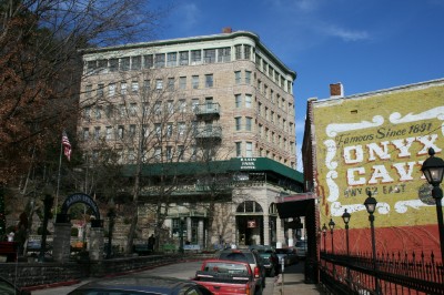
Eureka Springs, Arkansas
It often comes as a surprise visitors that the quaint Victorian town of Eureka Springs, Arkansas, hosts more weddings per capita than any city in the United States.

In fact, some years more people get married in Eureka Springs than actually live there! So I thought in honor of Valentine's Day it would be enjoyable to take a look at this charming community in the Ozark Mountains of Arkansas.

Eureka Springs has always been a special place. The first visitors came back in the late 19th century when dozens of mineral springs were found flowing from the sides of the mountains there. The town was founded in 1877 and in less than one year more than 3,000 people came to live in Eureka.

Historic Downtown of Eureka Springs
They came because of the popularity of mineral springs in those days. People believed the pure water provided cures for a variety of illnesses and the arrival of the railroad brought crowds in to enjoy the spas, hotels and other amenities of the resort community in the Ozarks.

The belief in the power of water from mineral springs diminished in the 20th century, but unlike many such places, Eureka Springs preserved its beautiful atmosphere and architecture. It stands today as one of the most beautifully preserved Victorian towns in the world. The romance of days gone by is unmistakable and the town offers beautiful historic accommodations, restaurants, shops and entertainment. Carriages roll through the streets and couples walk hand in hand along the sidewalks.

Crescent Hotel in Eureka Springs
And there are weddings. More weddings than can be imagined. There is no blood test and no waiting to get married in Eureka Springs. A couple can arrive, get their license, get married and be on their honeymoon in a beautiful historic hotel, bed and breakfast or more modern accommodation in less than 90 minutes.

An array of wedding locations are available, ranging from the simple to the elegant, or one of the town's many ministers will come to you and perform a wedding at the location of your choice. An overlook on East Mountain, for example, provides a spectacular view of the valley and Victorian town and is popular for couples looking to marry surrounded by the beauty of the mountains.

To learn more about Eureka Springs, please visit www.exploresouthernhistory.com/eurekaindex.

For complete information on getting married in Eureka Springs, please visit www.exploresouthernhistory.com/eurekaweddings.

Sunday, February 5, 2012

Historic Springs of Eureka Springs, Arkansas

Eureka Springs, Arkansas
The landscape of the South is dotted with towns and cities named after springs. There are Hot Springs, Warm Springs, Boiling Springs, Old Town Spring, Spring Hill, Winter Springs, Mineral Springs, Sylvan Springs, Holly Springs and the list goes on and on.
One of the most beloved such communities, however, is Eureka Springs. Located high in the mountains of the Ozarks, Eureka Springs is the number one wedding location per capita in the nation. More people go there to get married each year than actually live in the town.

Crescent Spring in Eureka Springs
Known for its beautiful scenery, inns, hotels, bed & breakfast inns, resorts, restaurants and unique shopping, Eureka Springs has done a marvelous job of preserving and restoring the historic springs that give the town its name.

A surprisingly large number of natural, mineral springs flow from the mountainsides surrounding the town. These springs were considered a source of health-giving mineral waters during the 19th century. Those were the days when crowds of people flooded to Eureka Springs to soak in its spring waters in hopes of finding miracle cures for physical and neurological illnesses.

Grotto Spring in Eureka Springs
The belief in the curative power of mineral springs faded in the 20th century, but Eureka Springs preserved its historic springs and today they add greatly to the charm of the beautiful Victorian community.

Probably the best known and photographed of the springs in Basin Spring, which is the centerpiece of a charming little park in the downtown area. Crescent Spring, down the mountain from the magnificent Crescent Hotel, is covered by a restored Victorian gazebo. A stone stairway leads up the mountain to the historic hotel itself.

Nearby is Grotto Spring, which flows from a natural grotto in the mountainside. History lovers also flock to Carrie Nation Spring, a natural spring that flows from the mountain across the road from the home of Carrie Nation, the famed ax-toting liquor fighter of the Prohibition era.

To learn more about Eureka Springs, its historic springs and other points of interest, please visit www.exploresouthernhistory.com/eurekaindex.

Thursday, February 2, 2012

Beauvoir in Biloxi, Mississippi - Final Home of President Jefferson Davis

Beauvoir, Final Home of Jefferson Davis
One of the most beautiful landmarks of the Mississippi Gulf Coast is the appropriately named Beauvoir, the last home of Confederate President Jefferson Davis.

The home survived the brutal winds and storm surge of Hurricane Katrina and his been restored to its pre-storm beauty. It faces across US 90 to Mississippi Sound and the Gulf of Mexico in the popular resort city of Biloxi.

Beauvoir in Biloxi, Mississippi
Built in 1848, the same year as the nearby Biloxi Lighthouse, Beauvoir originally was known as Orange Grove. Satsuma Oranges then grew in profusion on the grounds, as they once did across the entire northern Gulf Coast, giving the summer home of the James Brown family its name. Brown died in 1857 and his widow later sold the home to a real estate speculator who, in turn, sold it to Mrs. Sarah Dorsey.

Bedroom of Jefferson Davis
Mrs. Dorsey renamed the home Beauvoir (French for "Beautiful View") and in 1877 invited former Confederate President Jefferson Davis to use a pavilion on the grounds as a writing retreat. Two years later she agreed to sell the entire estate to Davis for $5,000, to be paid in three payments. Mrs. Dorsey died after receiving the first payment from Davis and the Southern leader was surprised to find that she had left Beauvoir to him in her will.

It was at Beauvoir that Davis completed his monumental work, The Rise and Fall of the Conferate Government and a shorter volume, A Short History of the Confederate States of America.

Now owned by the Mississippi Division of the Sons of Confederate Veterans, Beauvoir is open to the public daily and is a great place to explore the final years in the life of one of the most prominent Southerners of all time. The home features original furniture and other items that once belonged to the Davis family and the guides provide one of the best tours of a historic home that I've ever experienced.

To learn more about Beauvoir, please visit www.exploresouthernhistory.com/beauvoir.